levees
raised banks as coarse material is deposited near the channel as a result of repeated flooding
meander
the river erodes the outer bank of a bend and deposition occurs along the inner bank forming a point bar
waterfall
occurs on horizontally bedded rocks as soft rock is undercut by hydraulic action causing hard rock to collapse and retreat
suspension
the smallest particles are carried in the water
saltation
large particles hop along the river system
traction
pebbles shunt along the river bed
solution
material is carried in dissolved load
flotation
materials such as leaves and twigs are carried along the surface of the river
river erosion
the wearing away of land as water flows past the bed and bank
hydraulic action
the force of air and water going into cracks
attrition
wearing of load as rocks knock against each other
abrasion
the scraping away of the bed and bank
corrosion
chemicals in the river dissolves minerals in the rocks within the bed and bank, carrying them away in solution
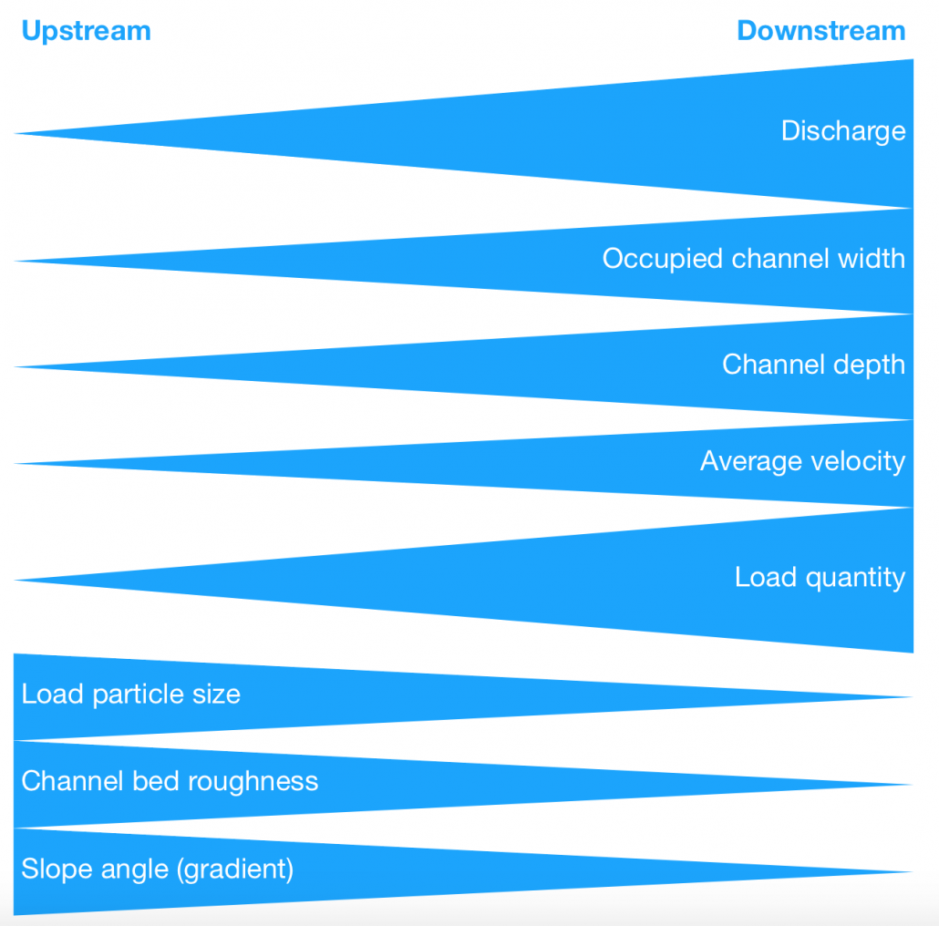
Bradshaw model
a model which shows how the size of the river affects stream flow
drainage basin
areas of land where precipitation drains downhill into a body of water
watershed
the boundary line of a drainage basin
source
the start of a river
tributary
a smaller river which joins the main river
confluence
the point where two rivers meet
floodplain
the area of land on either side of the river channel
mouth
the point where the river joins another body of water such as the sea
6275km
length of the Mississippi River
1400 million m3 per day
Discharge of the Mississippi River
7 meters
the height of the levee in New Orleans along the Mississippi River
3 meters
the height of the levee at Lake Pontchartrain along the Mississippi River
Morganza Spillway
the diversionary spillway built in 1973 along the Mississippi River
2016
the Mississippi dredging plan was completed in…
5 feet
the Mississippi dredging plan lowered the river bed by…
29
the number of locks and dams along the Mississippi river
1203 feet
the length of the largest lock and dam along the Mississippi River
44km
length of the River Otter
3.12m3 per second
discharge of the River Otter
30%
the % decrease of average peak flow of water downstream during storms after beavers were introduced to the River Otter
15
the number of beaver families currently living along the river otter
139km2
the size of lake Naivasha
30m
the maximum depth of Lake Naivasha
Gilgil and Malewa
the two main rivers feeding the wetland area of lake Naivasha
Oserian
a Dutch flower farm located on the south shores of Lake Naivasha, Kenya which is Africa’s largest rose producer
Lake Naivasha Riparian Association (LNRA)
a group of landowners on Lake Naivasha who established a 100m buffer zone to protect native papyrus and use of pesticides
Integrated Drainage Basin Management
the process of coordinating conservation, management and development, and related resources across sectors within a given river basin, in order to maximize the economic and social benefits
20% from the White Nile and 80% from the Blue Nile
where the full discharge from the Nile comes from
Kenya, Tanzania, Egypt, Ethiopia, Sudan, Uganda and South Sudan
countries the Nile flows through
238 million
the number of people living in the Nile drainage basin
1929 Nile Water Agreement
agreement between Egypt and Great Britain regarding the utilization of the waters of the Nile River which granted Egypt veto power over construction projects on the Nile or any tributaries
Sudan
the country with the longest section of the Nile
Grand Ethiopian Renaissance Dam
A hydropower project on the Blue Nile in Ethiopia, located 30km upstream of the border with Sudan.
6’450MW
GERD energy production capacity