


Chapter 8: Earth Systems and Resources
This chapter is all about the nonliving part of our planet that supports our living systems.
Earth’s systems interact, resulting in a state of balance over time.
Most of the Earth’s atmospheric processes are driven by input of energy from the sun.
Key Terms
Convergent boundaries: Where two tectonic plates are colliding together.
Divergent boundaries: Where two tectonic plates are moving apart.
Transform boundaries: Where two tectonic plates moving in opposite directions are sliding by one another.
Hot spot volcanism: A volcano created by the magma from the mantle rises through the lithosphere. If the lithosphere is moving over a stationary hot spot, you can get a line of volcanic islands.
Island arcs: A chain of volcanic islands found on subduction zones. There are usually earthquakes associated with these.
Erosion: Soil moving from one area to another caused by wind or water.
Soil horizons: Layers of soil that include O, A, B, C, and bedrock.
Porosity :Having small spaces between the particles. The finer the particle size, the more porosity. This might seem backward but clay has tiny holes and very fine particle sizes so clay has the highest porosity.
Permeability: The ability of a material to allow liquid to flow through it. Sand has a high permeability, since water flows easily through it.
Soil texture triangle: A way to determine the type of soil based on the percentage of clay, silt, and sand.
The layers of the atmosphere: Troposphere, stratosphere, mesosphere, thermosphere, and exosphere. The temperature changes with each layer.
Coriolis effect: Because the Earth is spinning on its axis, winds and water veer to the right, and storms like hurricanes spin counterclockwise in the Northern Hemisphere and clockwise in the Southern Hemisphere.
Watershed: A watershed is a land area that directs precipitation to a particular creek, stream, or river and eventually to the ocean.
Rain shadow effect: Where it rains on the side of the mountain with the ocean and is very dry on the other side of the mountain.
El Niño and La Niña: Are opposite phases of what is known as the El Niño–Southern Oscillation (ENSO) cycle. The ENSO are the fluctuations in temperature in the ocean and atmosphere in the east-central Equatorial Pacific.
Plate Tectonics
The Earth’s lithosphere, which includes the crust and upper mantle, is made up of a series of pieces, or tectonic plates, that move slowly over time (Figure 8.1).
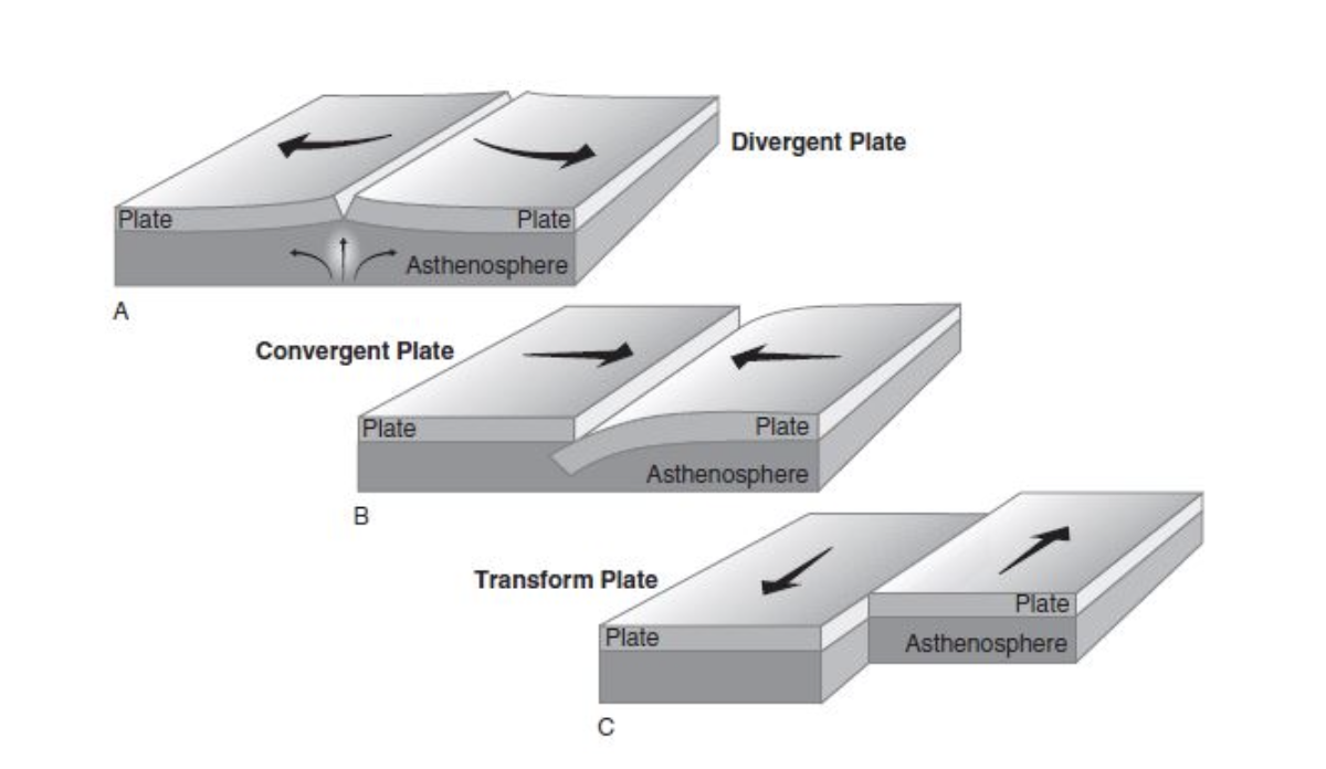
The first way plates move is away from each other at divergent plate boundaries.
When plates move apart we get seafloor spreading, rift valleys, volcanoes, and earthquakes.
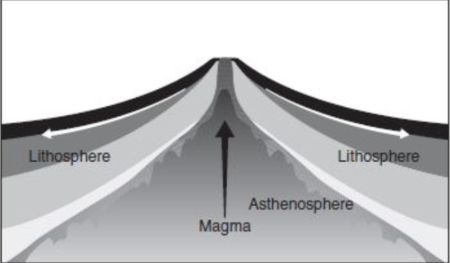
Along these boundaries, earthquakes are common and magma (molten rock) rises from the Earth’s mantle to the surface (Figure 8.2).
Once this magma solidifies we get new oceanic crust. The most common example of a divergent plate boundary is the Mid-Atlantic Ridge found in the middle of the Atlantic Ocean on the bottom of the seafloor.
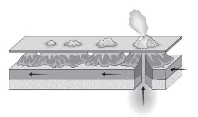
The second way plates move is together at convergent plate boundaries.
When two land (continental) plates come together, the land buckles and mountain ranges are formed.
The Himalayan Mountains are an example of this.
When a land plate and a sea (oceanic) plate collide, we get deep seafloor trenches with lines of volcanoes and earthquakes near them. The reason you will get a lot of volcanoes is seen in Figure 8.3.
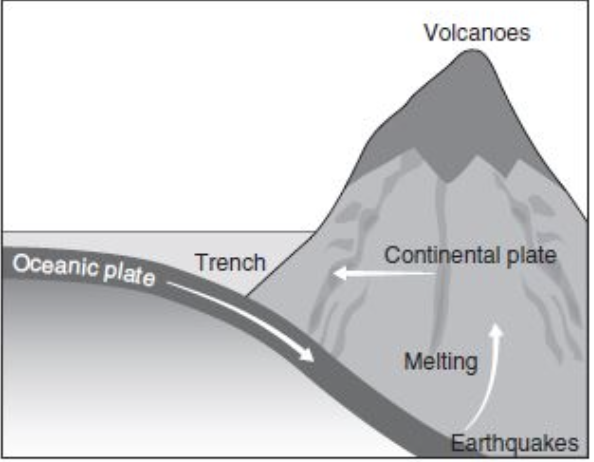
As the ocean plate subducts, or is forced below the continental plate, the ocean plate melts and rises.
Example: The wax (lava) is down on the bottom of the lamp where the heat source (light bulb) is found.
As the heat melts the wax, the wax begins to rise up through the liquid to the top; this is like what is happening on our planet.
As the ocean plate melts because of the heat in our Earth, it begins to rise forming a volcano.
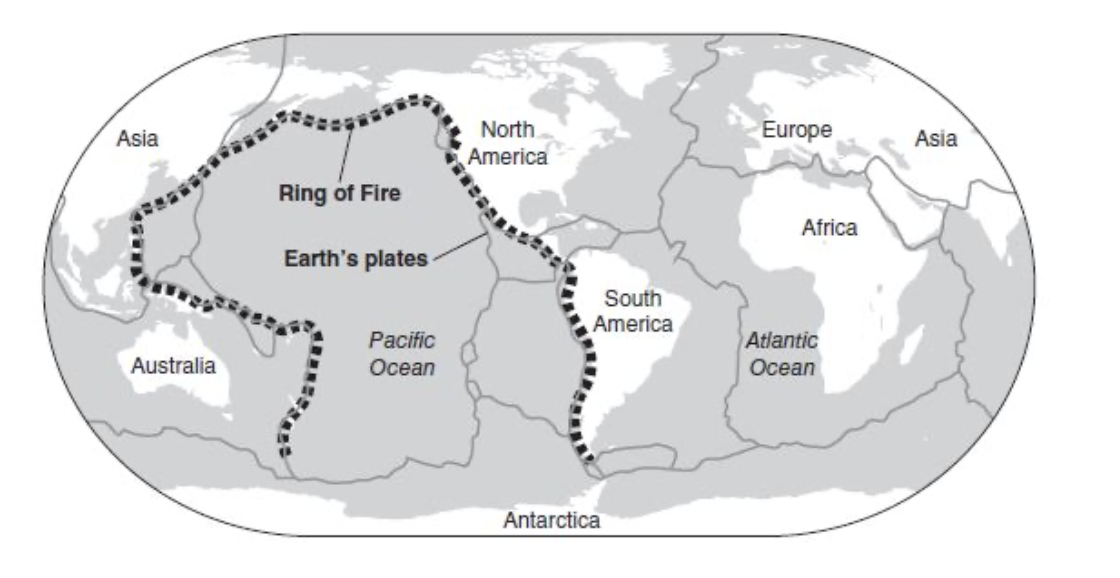
The Ring of Fire (see Figure 8.4) is an area around the Pacific Plate where a “ring” of volcanoes and earthquakes can be found because of convergent plate boundaries.
Island arcs are a chain of volcanic islands found on subduction zones and there are often earthquakes associated with these.
Examples of island arcs are the Japanese islands, Kuril Islands, and the Aleutian Islands of Alaska.
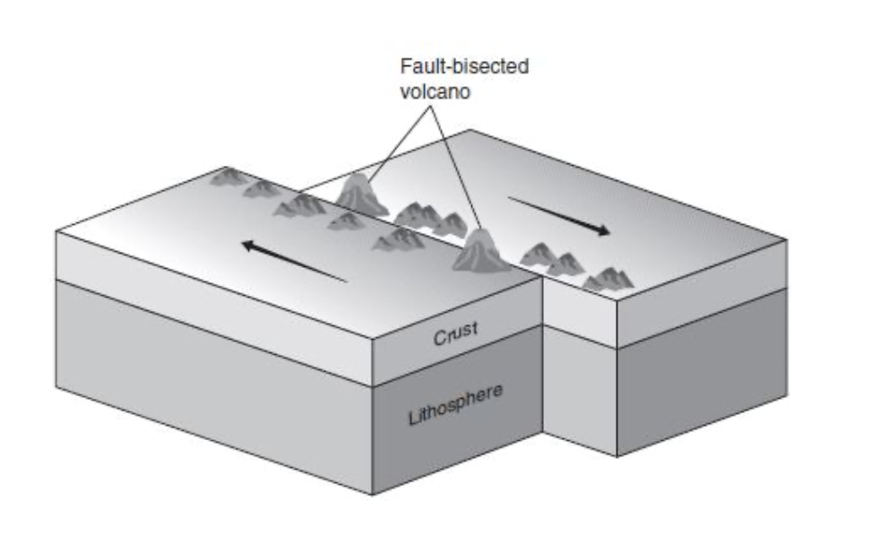
The final way plates move is at transform boundaries (Figure 8.5) where two plates moving in opposite directions slide by one another.
The most common example is California’s San Andreas fault.
Earthquakes are common along these faults as the plates move past each other and stored energy becomes released as energy of motion.
Hot spots are areas where the magma from the mantle rises through the lithosphere creating a volcano (Figure 8.6). If the lithosphere is moving over a stationary hot spot, you can get a line of volcanic islands.
The Hawaiian Islands are an example of a hot spot volcanism.
Soil Formation and Erosion
The topic of soil formation and erosion, as well as the next section on composition and properties of soil, will be tested in the context of a scientific experiment.
When rock is broken down (weathered) by rain, wind, snow, ice, and so on, and carried to another place and deposited, soil can be formed.
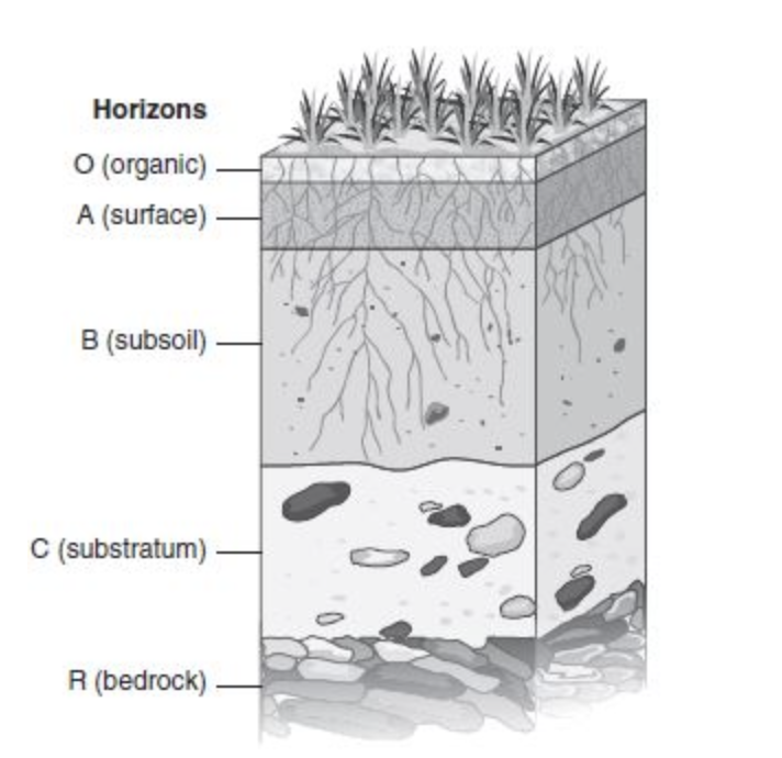
Soil is broken down by many horizons as shown in Figure 8.7.
The top layer is the “O” horizon, or organic layer, where freshly dead leaves and other organic matter are found. Lots of decomposition is happening here.
The second layer, the “A” horizon or surface layer, is often called topsoil and is rich in organic matter.
The “B” horizon, or subsoil, often has a lot of clay from above layers.
The “C” horizon, or substratum, is mostly weathered rock from the bedrock below.
Soil erosion can be caused from water and wind taking soil away.
It is very important to stop soil erosion because of the importance of soil for plants, the ability soil has to clean and filter water, and the concern that when soil erodes it can damage the local waterways.
Soil Composition and Properties
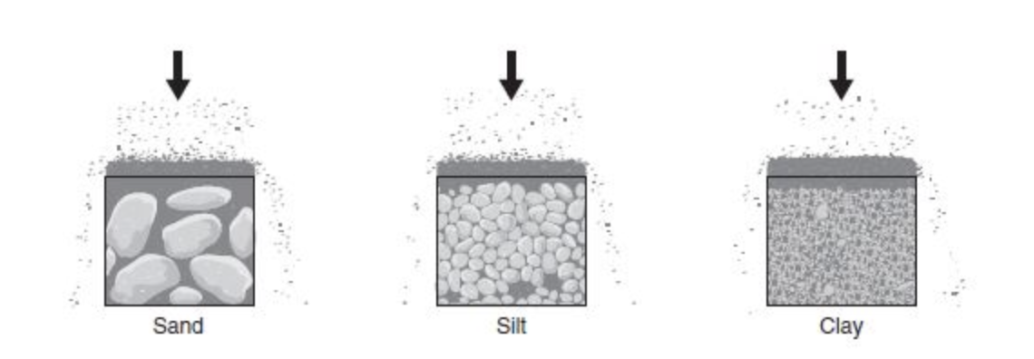
Different types of soil allow water through at different rates, or not at all.
For example, water goes easily through sand since the water is smaller than the particles of sand.
Water can go through silt slower, because silt particles are smaller.
Water can’t go through clay at all because the particles of clay are so small that water can’t squeeze between them (Figure 8.8).
The type of soil determines how much water the soil can hold, or the soil’s water-holding capacity.
Example: clay is used to make things like pots and bowls, because clay has a high water-holding capacity. It can hold water for days.
You wouldn’t make a cup out of sand because the water would go right through the sand because sand has a low water-holding capacity.
How much water the soil can hold can also determine how fertile the soil is and how productive the land might be.
Porosity: Having small spaces between the particles. The finer the particle size, the more porosity.
This might seem backward but clay has tiny holes and very fine particle sizes so clay has the highest porosity.
Permeability: The ability of a material to allow liquid to flow through it. Sand has a high permeability since water flows easily through it.
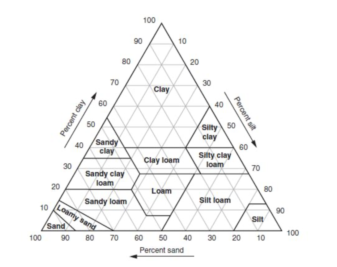
You may be asked to read a soil triangle and determine the type of soil based on the percentage of sand, silt, and clay. A soil triangle looks like Figure 8.9.
You may be given information such as: a soil has 40 percent sand, 40 percent silt, and 20 percent clay. You would be asked to determine the type of soil texture using the soil pyramid.
To do this, you start with the sand and find the percentage along the bottom of the triangle, in this case 40 percent, and follow the line that goes up and to the left for sand.
Then, you move to the right side of the triangle and find the line for silt, in this case also 40 percent.
Follow this line down and to the left until it hits the line you had drawn for sand. They should cross.
Then, where they cross, if you draw a straight line to the left, where you find clay, you should be at the 20 percent line, which is your percentage of clay.
Where these three lines intersected is the type of soil you have; in this case, loam.
You might want to use a ruler or a straight edge when drawing the three lines to make sure you are accurate.
Earth’s Atmosphere
The Earth’s atmosphere is mostly made of nitrogen gas.
In fact, 78 percent of the atmosphere is nitrogen.
The next highest is oxygen, making up 21 percent, followed by argon, which is 0.9 percent.
The rest of the atmosphere is made up of what are known as trace gases, including carbon dioxide, methane, nitrous oxides, and ozone.
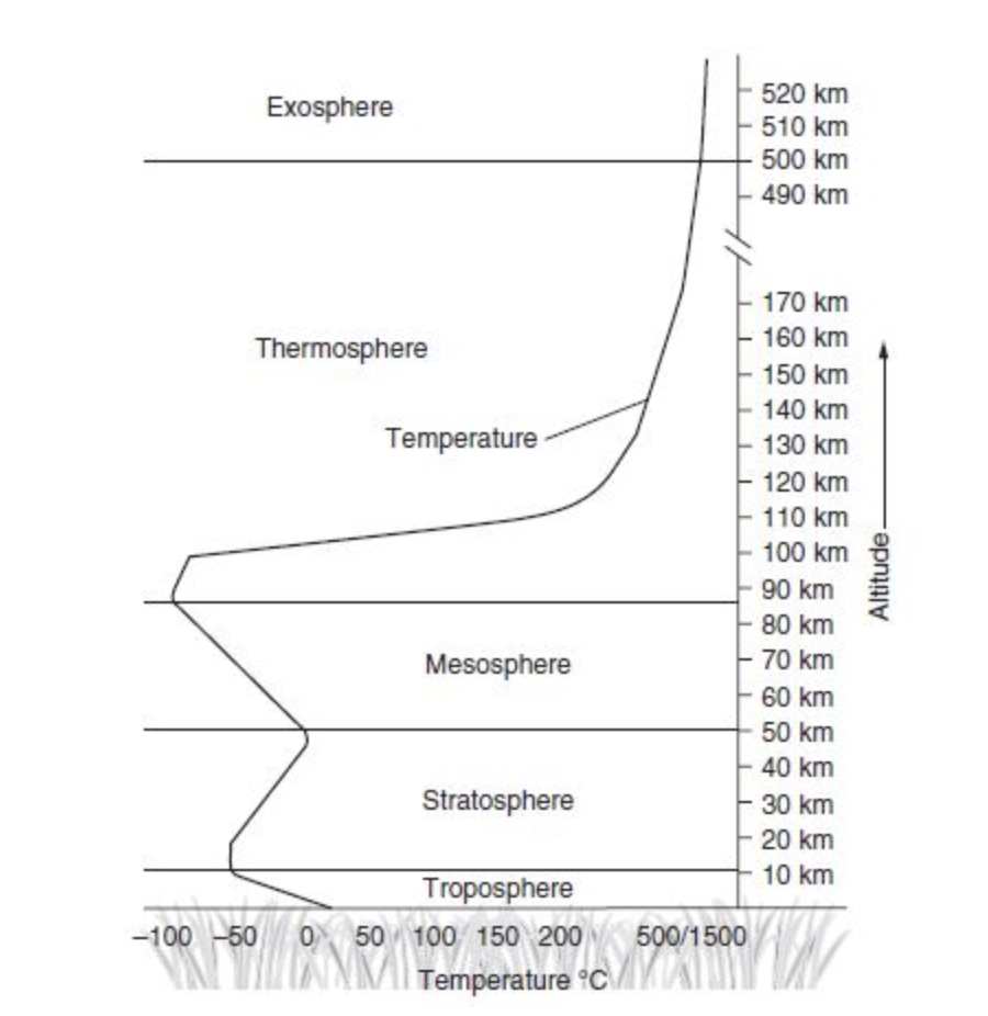
The Earth’s atmosphere has layers as you move away from the land; the layers are seen in Figure 8.10.
The layer we live in is called the troposphere, where all weather occurs.
The layer that is farthest away is the exosphere.
You can see the temperature line going up through each layer. As you move up through the troposphere, the temperature gets colder. Once you hit the stratosphere, the temperatures begin to go in the other direction, heating up.
This back-and-forth continues as you move up through each layer. The thermosphere (thermo means “heat”) has temperatures that reach hundreds to thousands of degrees!
But, the air is so thin it would feel freezing cold to us if we went there.
Global Wind Patterns
Look at Figure 8.11. The Earth is tilted at a 30-degree angle. Because of this, the sun’s radiation hits the Earth with different intensities.
It hits the equator most directly since it is directly overhead most of the year.
Remember that warm air rises and cooler air sinks because warm air is less dense than cold air.
So, if you look at the 0-degree equator, you see rising, moist air that goes off in both directions and sinks at 30 degrees north and south.
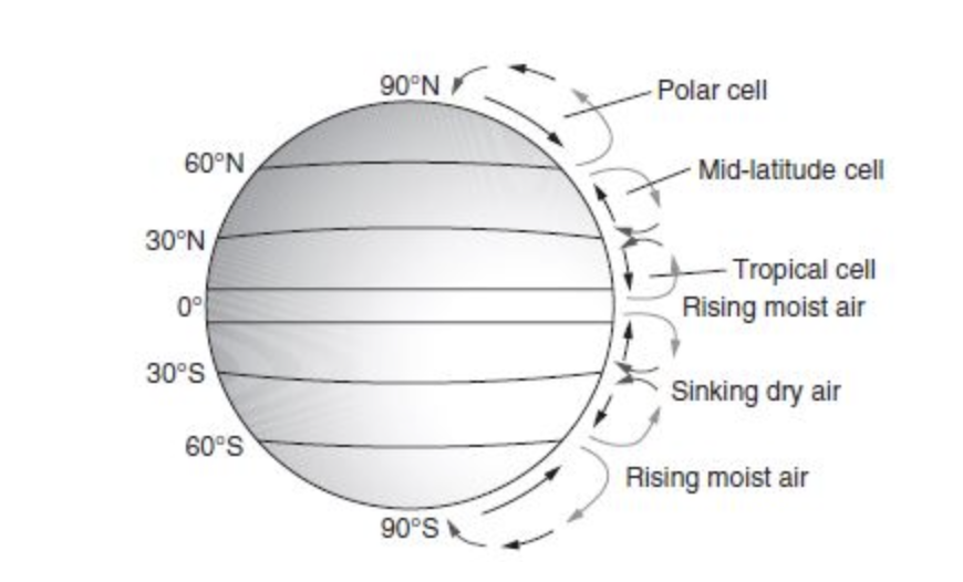
This sinking, dry air is where the Earth’s major deserts are found.
Air is also rising at the 60-degree line (both north and south) going off in both directions and sinking again at 30 degrees or at 90 degrees.
These different cells are responsible for the climate patterns that define our biomes.
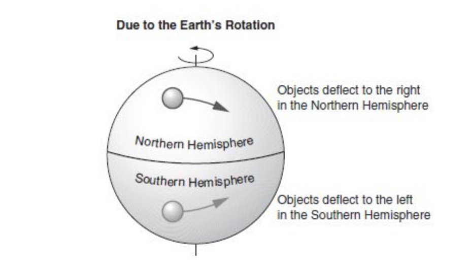
Coriolis effect: Because the Earth is spinning on its axis, winds and water veer to the right, and storms like hurricanes spin counterclockwise in the Northern Hemisphere and veer to the left and spin clockwise in the Southern Hemisphere (Figure 8.12).
Watersheds
A watershed is a land area that directs water or snow to a river, creek, or stream and eventually to the ocean.
Some watersheds are very large, lthike the Mississippi River watershed that covers about 40 percent of the United States.
Watershed characteristics such as size, slope, shape, drainage density, land use/land cover, geology, soils, and vegetation are important factors of watersheds.
Things that can affect a watershed would be a dam and housing developments.
Solar Radiation and Earth’s Seasons
Our Earth is tilted 23.5 degrees and solar radiation hits the planet at different intensities depending on the season and latitude. Look at the visual representation shown in Figure 8.13.
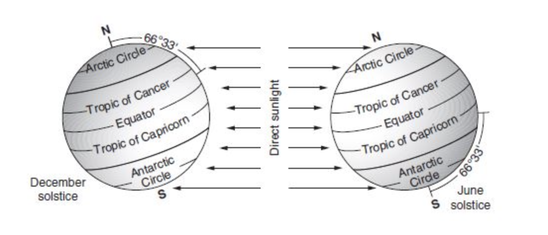
The diagram on the left is the Earth in December.
The Tropic of Capricorn is receiving the most direct (straight) sunlight in December.
Now, look at the diagram on the right; this is the Earth in June.
The most direct sunlight now is the Tropic of Cancer.
The amount of sunlight varies seasonally. In addition, the equator gets direct sun year-round and as you move up or down to the poles the sunlight becomes less and less direct.
The fact that the Earth is tilted and rotates around the sun accounts for the Earth’s seasons.
Earth’s Geography and Climate
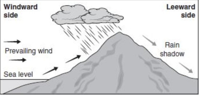
Figure 8.14 shows the rain shadow effect. Our planet’s weather and climate are impacted by other things in addition to the tilt of the Earth and the amount of sunlight.
Weather and climate can be impacted by things like tall mountains.
In the picture, the ocean is on the left, which provides a lot of moisture to the area.
As the moisture evaporates and clouds are formed, there is a lot of rain on the windward side of the mountain.
However, because the mountain is so tall, the rain clouds don’t go over the mountain and it is very dry on the other side.
El Niño and La Niña
Every three to seven years on average, the Pacific Ocean has climate shifts with warmer surface waters known as the El Niño–Southern Oscillation (ENSO).
Upwellings from the seabed occur in normal years that bring nutrients up for the plankton to feed on. Plankton are food for the marine life up the food chain.
In an El Niño year, that upwelling does not occur so the plankton decrease and, in turn, so do the fish stocks.
La Niña is essentially the opposite of El Niño.
With La Niña, the trade winds are particularly strong in carrying warmer water westward across the Pacific leading to colder than average temperatures in the east and warmer than average temperatures in the west.
The result is that plankton increase in the areas where the temperature is cooler, leading to an increase in fish stocks.
The impacts of El Niño and La Niña are changes to rainfall, wind, and ocean circulation patterns.
It is particularly rainy during an El Niño year on the West Coast of the United States and South America.