mechanical weathering
freeze thaw, water gets into cracks, feezes and widens the crack
biological weathering
roots of plants grow in cracks
chemical weathering
acid is present in rain which reacts with minerals in rocks to dissolve them
sliding (mass movement)
gravity pulls rock matter down a slope
slumping (mass movement)
the river erodes the bottom of a valley slope whcih cases material above to slide downwards specifically if saturated in water
traction
large boulders roll along the river bed
saltation
smaller pebbles bounced along the river bed
suspension
finer particles of sediment suspended in the water giving river a brown appearence
solution
dissolved minerals in the river stream e.g chalk
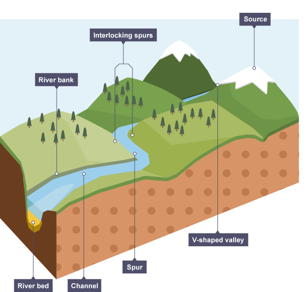
source
where a river starts
mouth
where a river joins the sea
long profile
the makeup of a river as it flows
discharge
amount of water in a river
gradient
steepness of a river
where is a v shaped valley found
upper course
upper course features
steep gradient, small discharge, shallow, narrow with steep sides, large angular boulders of sediment
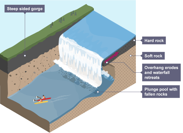
where are waterfalls found
upper course
where are interlocking spurs found
upper course
middle course features
less steep gradient, large discharge, deep, flat steep sides, fast, rounded rocks transported through saltation
where are meanders found
middle and lower course
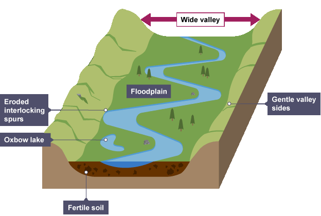
where are floodplains found
middle and lower course
lower course features
shallow gradient, very large discharge, deep, flat riverbed with gently sloping sides, smooth rounded pebbles with saltation
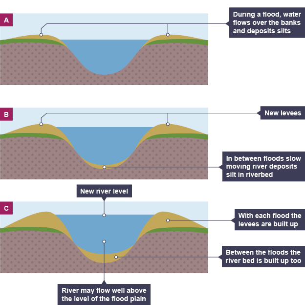
where are leves found
lower course
where are oxbow lakes found
lower course
what happens to the soil during cold conditions
it becomes impermeable due to snow covering it making areas with rivers prone to flooding
what happens to the soil during hot conditions
the top layer bakes causing it to be impermeable and increased surface runoff directing water into rivers
interlocking spurs
where water of low energy and low discharge flows around ridges in the valley of hard rock causing the stream to form a zig zag pattern, found in the upper course of a river
waterfalls
where a river undercuts hard rock through hydraulic action forming a plunge pool and making a waterfall
gorge
a steep sided valley where a waterfall once was, usually having a river running through it, its what a waterfall leaves behind as it retreats
floodplain
area around the river that is prone to flooding, layers of aluvium are deposited here when the flood looses energy building the floodplain up
levee
the embankments on the side of rivers naturally created by the deposiotion of heavy sediment during a flood, building the river bank up
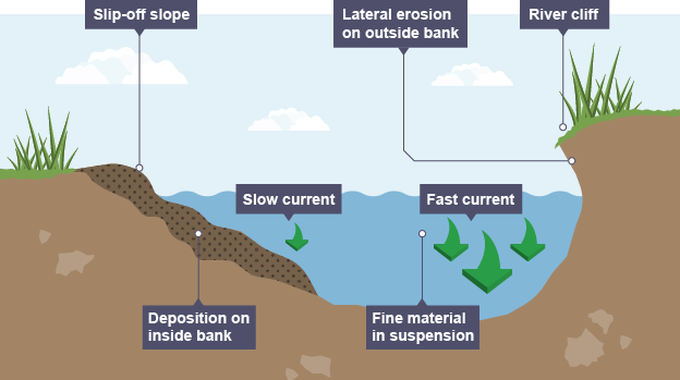
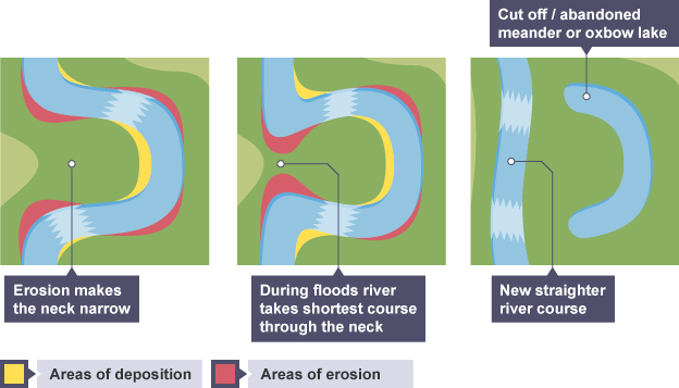
meander
lateral (sideways) erosion causing large bends to form called meanders, material is eroded on the outer edge where the current is greatest creating a river cliff, this material gets deposited on the inner edge causing point bars
river cliff
where the lateral erosion of a river causes the river bank to be undercut causing a small cliff
oxbow lake
the neck of a meander is slowly eroded as the water takes the quickest route, deposiotion seals off the meander, an oxbow lake is left and completely dettatched from the meander
impermeable
water cannot penetrate/ infiltrate rocks
surface runnoff
where water is unable to saturate into the ground so it sits on the surface
relief
the steepness of a valley, steeper valleys will flood faster as water moves with more velocity
why does urbanisation affect river landcapes *2 reasons
citys full of impermeable rock e.g concrete are built meaning water cannot seep through rocks and it just sits on top, more houses are built on flooplains changing the natural landscapes
how does deforstation affect flooding
there are less trees to intercept the rainfall which helps to reduce surface run off removing them means water reaches rivers quicker
how do fields on slopes affect rivers
the sediment from the fiekds being ploughed increases the amount of sediment eventually ending up in rivers heightening the risk of flooding
what can the industry do to rivers
pollute them with chemicals, use the water up
name 4 causes of flooding
rainfall intensity, geology, snowfall, drainage basin
rainfall intensity
lots of rain falling preventing infiltation
geology
land may consist of less permeable rocks than others causing water to sit on the top of the land
snowfall
warmer temperatures in cold climates melt snow causing a higher volume of water and more discharge in the river
drainage basin
an increase in tributaries leading to a river may casue it to flood due to more discharge
hard engineering
man made structures acting as defenses to prevent rivers flooding
dams and reservoirs + pros and cons
barries constructed to hold back water in artificial lakes. pros= long-lasting, can be used to generate hydroelectric power, can store large volumes of water. cons= expensive, sediment can build up over time, floods the original landscape
channelisation + pros and cons
deepening or widening the river channel replacing the natural meanders and flooplain. pros= allows water to flow quickly away from areas of flood risk. cons= ugly, more water is taken downstream increasing the flood risk to settlements
embankments + pros and cons
making a river taller to increase the dishcharge its able to hold. pros= one off cost, flood water is contained in channel. cons= unnatural, water speeds up causing more issues downstream
soft engineering
use of natural processes to reduce the impacts of river flooding
floodplain zoning + pros and cons
where areas near the river (floodplains) are not able to be built on. pros= reduces homes flooding, allows infiltration, protects and preserves natural floodplain. cons= limits settlement growth
washlands + pros and cons
deliberate flooding in order to prevent thje river flooding to more important areas. pros= creates area for flood to go, allows for natural processes, preserves floodplains. cons= limits use of land
flood warnings and preperation + pros and cons
warning people about the floods coming. pros= effective and gets the message across, reduces insurance claims as people know what to expect. cons= dont do anything about the flood, may be too late
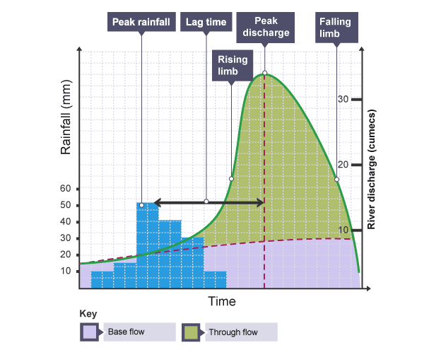
hydrograph
graph showing how a river reacts to prolonged amounts of rainfall
peak discharge
maximum amount of water held in the channel
peak rainfall
maximum amount of rainfall (millimetres)
lag time
the time taken between peak rainfall and peak discharge
rising limb
shows the increase in discharge on a hydrograph
falling limb
shows the return of discharge to normal/base flow on a hydrograph
base flow
the normal discharge of the river