what is fetch
refers to the distance of open water over which a wind can blow, it determines the length of time and distance over which wind can generate waves
How do prevailing winds play a role in coastal mass movements?
wave energy and wave patterns are influenced
they can dictate the direction of sediment transport along the coast. winds blowing parallel to the coastline can lead to the accumulation of sediment at certain locations of the erosion of others
wind driven water currents like long shore drift and rip currents can transport sediment along the shoreline
the growth patterns of vegetation along the coastline
what is the problem with a narrow beach
there is less sediment available to absorb the energy from the waves and storm surges.
it also provides less protection from wave action which can undercut the base of the cliffs
limited space for sediment redistribution, this can result in it accumulating at the base of the cliffs and increasing the pressure on them
how does the width of a beach effect erosion and mass movements
a wider beach typically provides more sediment buffer, reducing the impact of waves and storm surges and therefore reducing erosion rates
how does tourism increase the risk of mass movements
Tourism can lead to deforestation, soil erosion, and destabilization of slopes, increasing the likelihood of landslides and avalanches.
what is dredging
Dredging is the process of removing sediment or debris from the bottom of bodies of water to maintain navigation channels or restore ecosystems.
what is refraction
this is where the waves bend, as some slow down after hitting the shallow ledge but the parts of the wave that dont, continue at the fast rate, causing it to bend
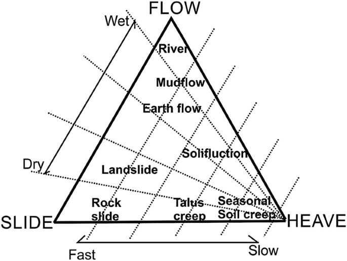
Mass movement model
how are cuspate deltas formed, what shape are they and one example
It is formed where sediments are deposited onto a straight shoreline with strong waves. The waves push the sediments to spread outwardly creating the tooth-like shape. Example, Tiber River of Italy.
what shape are arcuate deltas
Deltas with this triangular or fan shape are called arcuate (arc-like) deltas. The Nile River forms an arcuate delta as it empties into the Mediterranean Sea.
what are the three main types of deltas
Acuate delta
Cuspate delta
Birds-foot delta
what causes channel braiding
a steep channel gradient
a large proportion of coarse material
easily erodable bank material
highly variable discharge
what is a point bar
semi-circular sand or gravel deposits located on the inner banks of a meander
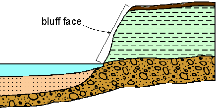
how are bluffs formed
It is an active bluff if there is a river eroding it, but most bluffs are from past river meanders eroding it as they migrate downstream. they undercut the floodplain which collapses and leaves the bluff
what is a bluff.
a line of steep cliffs or land parallel to the floodplain
what is a riffle?
Riffles are areas of shallow water in the straight sections of the channel between meanders
small ridges of deposited sediment (gravel sized)
What is a pool
A deeper section of a river bed found on the outside edge of a meander
what is helicoidal flow
Helicoidal flow is a type of flow pattern where the fluid moves in a spiral or helix-like motion.
what does sinuous mean
Sinuous means having many curves and turns, like a winding river or a twisting road.
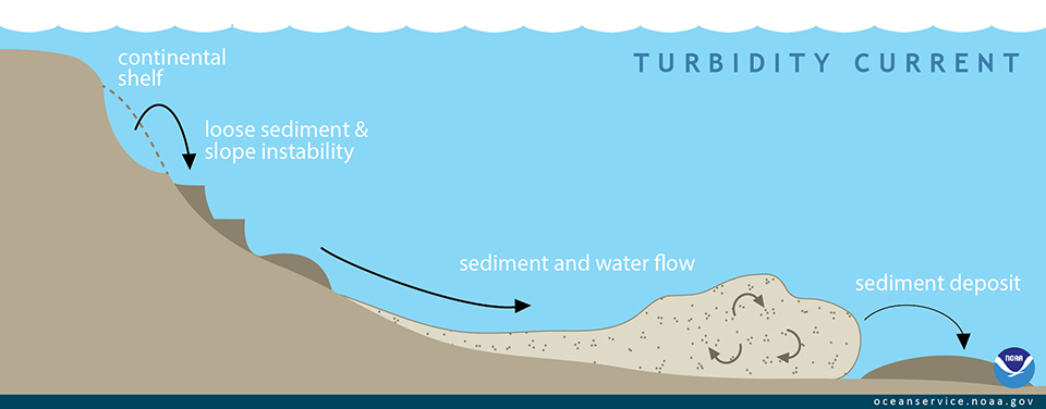
what are turbity currents
Turbidity currents are fast-moving underwater flows that transport sediment down continental slopes, forming submarine canyons.
what is alluvium
Alluvium is loose sediment deposited by flowing water, such as rivers and streams, containing sand, silt, and clay particles.
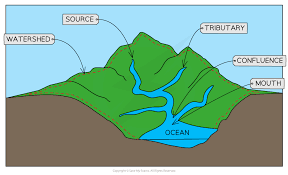
what is the drainage basin
A drainage basin is an area of land where all the water drains into a common outlet, such as a river, lake, or ocean.
What is the watershed
the area of land around the river that is drained
Asthenosphere
Semi-fluid layer beneath the lithosphere where tectonic plates move
Magma Chamber
Reservoir of molten rock beneath the Earth's surface
Oceanic-Oceanic Subduction Zones
Convergent boundaries where one oceanic plate subducts under another
Friction
Force that opposes motion between surfaces in contact
Partial Melting
Process where only a portion of a rock melts
Water Content
Affects the melting point of the mantle in subduction zones
where do volcanic island arcs form?
Forms 150km to 200km away parallel to the plate margin
Subduction
Process where one tectonic plate moves under another
Accretionary Wedge
Accumulation of sediment scraped off a subducting plate
Lithosphere
Rigid outer layer of Earth, including the crust and upper mantle
Earthquakes
Seismic events caused by the release of stress along faults
Enhanced Greenhouse Effect
Increased heat retention due to human activities
Radiation Cooling
Cooling of the Earth's surface by radiating heat
Precession
Wobbling motion of Earth's axis
Meander Loops
Curves in a river's path caused by erosion and deposition
Frontal Precipitation
Rain caused by a front of warm and cold air colliding
Orographic Precipitation
Rainfall due to air being forced up a mountain
Advectional Fog
Fog formed by warm, moist air moving over a cold surface
Valley Fog
Fog formed in valleys due to cooling of air
Long Wave Radiation
Radiation of heat from the Earth's surface
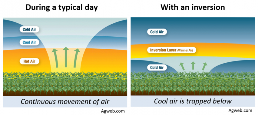
Temperature Inversion
A layer in the atmosphere in which air temperature increases with height
Contact Cooling/Conduction
Cooling by direct contact with a cooler surface
Urban Heat Island
Urban area with higher temperatures than surrounding rural areas
Down Draughts
Sudden downward movement of air
Venturi Effect
Reduction in air pressure when it flows through a narrow section
Milankovitch Cycles
Cycles in Earth's orbit affecting climate variations
Obliquity
Earth's axial tilt angle variation over time
Sunspots
Dark spots on the sun's surface affecting climate
Albedo
Reflectivity of a surface
Porosity
Measure of empty spaces in a material
Permeability
Ability of a material to allow fluids to pass through
Specific Heat Capacity
is a property that describes how much energy is needed to change the temperature of a material. Objects with a high specific heat capacity require a greater change in energy to change their temperature
Hydrology
Study of water distribution and movement on Earth
Fluvial geomorphology
Study of landforms produced by flowing water
Drainage basin system
Area of land where all precipitation flows to a common outlet
Evapotranspiration
Combined process of water evaporation from soil and transpiration from plants
Interception
Precipitation caught and stored by vegetation before reaching the ground
Infiltration
Process of water seeping into the soil
Percolation
Downward movement of water through soil and rock
Groundwater recharge
Refilling of underground water sources
Hydrograph
Graph showing the discharge of a river over time
Porosity
Measure of the open spaces in rocks or soil
Permeability
Ability of rock or soil to allow water to flow through it
Abrasion
Erosion caused by the scraping of materials along a surface
Cavitation
Formation and collapse of vapor cavities in a liquid
Traction
Transport of sediment by rolling or sliding along the ground
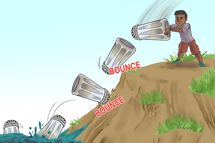
Saltation
Transport of sediment in short jumps or bounces
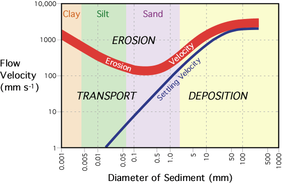
Hjülstrom curve
Graph showing the relationship between water velocity and sediment transport
Thalweg
Line connecting the lowest points along a river channel, thus the line of fastest flow
Deforestation
Clearing of trees from a forested area
Levées
Natural embankments along a river channel
Recurrence intervals
Average time between floods of a certain magnitude
Hard engineering
Structures built to control natural processes, like dams or levees
Slope Processes
Weathering, erosion, transport and deposition of the material.
Plate Tectonics
Movement and interaction of Earth's lithosphere plates.
Sea Floor Spreading
Process where new oceanic crust is formed through volcanic activity
Subduction
One tectonic plate moving under another
Fold Mountains
Formation of mountains through tectonic plate movement and the folding of the earths crust
Weathering
Breakdown of rocks into smaller particles through physical chemical or biological processes
Physical Weathering
Mechanical processes like freeze-thaw and root action breaking down rocks.
Chemical Weathering
Rock breakdown due to chemical reactions like hydrolysis and carbonation.
Factors Affecting Weathering
Influences like climate, rock type and vegetation
what are the human impacts on slopes?
Can effect the shear strength of a slope as well as the shear stress on the slope.
Mass Movement
bulk movements of soil and rock debris down slopes in response to the pull of gravity
Strategies to Modify Slopes
Methods like pinning, netting, and afforestation to reduce mass movements. undercutting and also terracing of the slopes changed the slope
Diurnal Energy Budgets
Calculations of energy exchanges within a day.
Albedo
Measure of surface reflectivity to incoming solar radiation.
Sensible Heat Transfer
Heat exchange between the surface and the air.
Latent Heat Transfer
the heat added to an object in order for it to change state.
Global Energy Budget
Balance of energy entering and leaving Earth.
Wind Belts
Global patterns of prevailing winds.
Ocean Currents
Continuous, directed movement of ocean water.
Convection
Transfer of heat through fluid movement.
Frontal Uplift
Lifting of air due to colliding air masses.
Orographic Uplift
Air forced to rise over a mountain barrier.
Enhanced Greenhouse Effect
Increased heat retention due to human activities.
Urban Heat Island
Urban area with higher temperatures than surroundings.